Back Manlleu AN مانليو Arabic Manlleu AST مانیئو AZB Manlleu Catalan Манльеу CE Manlleu (munisipyo) CEB Manlleu German Manlleu DIQ Manlleu Esperanto
Manlleu | |
|---|---|
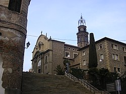
 Church of Santa Maria. | |
 Location of Manlleu | |
| Coordinates: 42°00′0″N 2°17′1″E / 42.00000°N 2.28361°E | |
| Country | Spain |
| Autonomous community | Catalonia |
| Province | Barcelona |
| Comarca | Osona |
| Government | |
| • Mayor | Alex Garrido Serra (2015)[1] |
| Area | |
• Total | 17.2 km2 (6.6 sq mi) |
| Elevation | 461 m (1,512 ft) |
| Population (2018)[3] | |
• Total | 20,194 |
| • Density | 1,200/km2 (3,000/sq mi) |
| Demonym | Manlleuenc |
| Time zone | UTC+1 (CET) |
| • Summer (DST) | UTC+2 (CEST) |
| Postal code | 08560 |
| Website | manlleu |
Manlleu (Catalan pronunciation: [məɲˈʎew]) is municipality in the comarca of Osona, in the province of Barcelona, Catalonia, northern Spain.
Manlleu is located in a large plain, La Plana de Vic, at around 460 metres above sea level on average. The highest point is Puig Agut church at around 594 m above the sea level. It is surrounded by mountains with altitudes over 1000 m.
The Ter River, which starts in the Pyrenees, snakes through Manlleu, and ends in the Mediterranean Sea, near Pals and the Illes Medes.
- ^ "Ajuntament de Manlleu". Generalitat of Catalonia. Retrieved 2015-11-13.
- ^ "El municipi en xifres: Manlleu". Statistical Institute of Catalonia. Retrieved 2015-11-23.
- ^ Municipal Register of Spain 2018. National Statistics Institute.


